
SÃO PAULO METRO MAP
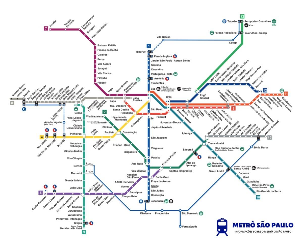
On this website you will find all the information you need about the São Paulo metro map. What’s more, if you prefer, you have the option to view online or download the São Paulo map.
For passengers who are not yet fully familiar with the connections when using the São Paulo Metro to reach their destination, we suggest using a printed or digital map that can be useful at any time during the journey, should it be needed.
São Paulo Metro Map
By clicking the button below, you can get the São Paulo map with the location of the stations. You can save the file to your device or print it as you prefer:
What can we see on the SP metro map?
As you navigate the map, you will find the following information:
- Location of all stations.
- Identification of all the metro lines, each with its distinctive colour.
- Marking of the stations where you can change lines or connect with other forms of public transport.
- A representation of the complete routes of each metro line.
- Location of points of interest near the stations.
At which stations on the SP map can you make a transfer?
The stations that have interchanges for transfers between lines are as follows:
- At Luz station, you can change between lines 1, 4, 7, 10 and 11.
- At Sé station, you can change between lines 1 and 3.
- At Paraíso and Ana Rosa stations, you can change between lines 1 and 2.
- At Santa Cruz station, you can change between lines 1 and 5.
- At Brás station, you can change between lines 3, 10, 11 and 12.
- At Tatuapé station, you can change between lines 3, 11 and 12.
- At Eng. Goulart station, you can change between lines 12 and 13.
- At Calmon Viana station, you can change between lines 11 and 12.
- At Osasco and Altino stations, you can change between lines 8 and 9.
- At Pinheiros station, you can change between lines 4 and 9.
- At Santo Amaro station, you can change between lines 5 and 9.
- At Tamanduateí station, you can change between lines 2 and 10.
- At Paulista and Consolação stations, you can change between lines 2 and 4.
- At Chácara Klabin station, you can change between lines 2 and 5.
- At Vila Prudente station you can change between lines 2 and 15
- At República station, you can change between lines 3 and 4.
- At Palmeiras – Barra Funda station, you can change between lines 3, 7 and 8.
Tickets for transferring and checking your available balance
You will find detailed information about tickets. You can also check your Bilhete Único balance with the tool available in the button below:
What colours are the lines on the SP metro map 2026?
On each of the available maps, you will be able to locate all the stations associated with each line, their connections with other lines and their course along the route. In addition, each line is identified with a unique colour to make it easier to recognise on the map.
The Blue Line is Line 1.
The Green Line is Line 2.
The Red Line is Line 3.
The Yellow Line is Line 4.
The Lilac Line is Line 5.
Line 7 in ruby.
Line 8 in diamond.
Line 9 in emerald.
Line 10 in turquoise.
Line 11 in coral.
Line 12 in sapphire.
Line 13 in jade.
The Silver Line is Line 15.
Distinguishing the lines by different colours means metro passengers can find their way around the São Paulo metro map with ease.
In addition, this can be especially useful for travellers who do not speak Portuguese, as it gives them an easier way to find their way around this public transport system.
The points on the map where two lines cross with their respective colours are where the connections between one line and another are made. At these stations, you can transfer between the different metro lines.
What are the lines on the 2026 São Paulo metro map like?
LINE 2 (GREEN)
- Vila Prudente Station
- Tamanduateí Station
- Sacomã Station
- Alto do Ipiranga Station
- Santos-Imigrantes Station
- Chácara Klabin Station
- Ana Rosa Station
- Paraíso Station
- Brigadeiro Station
- Trianon-Masp Station
- Consolação Station
- Clínicas Station
- Santuário Nossa Senhora de Fátima-Sumaré Station
- Vila Madalena Station
LINE 3 (RED)
- Corinthians-Itaquera Station
- Artur Alvim Station
- Patriarca-Vila Ré Station
- Guilhermina-Esperança Station
- Vila Matilde Station
- Penha Station
- Carrão-Assaí Atacadista Station
- Tatuapé Station
- Belém Station
- Bresser-Mooca Station
- Brás Station
- Pedro II Station
- Sé Station
- Anhangabaú Station
- República Station
- Santa Cecília Station
- Marechal Deodoro Station
- Palmeiras-Barra Funda Station
LINE 4 (YELLOW)
- Vila Sônia
- São Pualo Morumbi
- Butantã
- Pinheiros
- Faria Lima
- Fradique Coutinho
- Oscar Freire
- Paulista Pernambucanas
- Higienópolis-Mackenzie
- República
- Luz
LINE 5 (LILAC)
- Capão Redondo
- Campo Limpo
- Vila das Belezas
- Giovanni Gronchi
- Santo Amaro
- Largo Treze
- Adolfo Pinheiro
- Alto da Boa Vista
- Borba Gato
- Brooklin
- Campo Belo
- Eucaliptos
- Moema
- AACD-Servidor
- Hospital São Paulo
- Santa Cruz
- Chácara Klabin
LINE 7 (RUBY)
- Luz Station
- Palmeiras-Barra Funda Station
- Água Branca Station
- Lapa Station
- Piqueri Station
- Pirituba Station
- Vila Clarice Station
- Jaraguá Station
- Vila Aurora Station
- Perus Station
- Caieiras Station
- Franco da Rocha Station
- Baltazar Fidélis Station
- Francisco Morato Station
- Botujuru Station
- Campo Limpo Paulista Station
- Várzea Paulista Station
- Jundiaí Station
LINE 8 (DIAMOND)
- Júlio Prestes Station
- Palmeiras-Barra Funda Station
- Lapa-Senac Station
- Domingos de Moraes Station
- Imperatriz Leopoldina Station
- Presidente Altino Station
- Osasco Station
- Comandante Sampaio Station
- Quitaúna Station
- General Miguel Costa Station
- Carapicuíba Station
- Santa Terezinha Station
- Antônio João Station
- Barueri Station
- Jardim Belval Station
- Jardim Silveira Station
- Jandira Station
- Sagrado Coração Station
- Engenheiro Cardoso Station
- Itapevi Station
- Santa Rita Station
- Ambuitá Station
- Amador Bueno Station
LINE 9 (EMERALD)
- Osasco Station
- Presidente Altino Station
- Ceasa Station
- Villa Lobos-Jaguaré Station
- Cidade Universitária Station
- Pinheiros Station
- Hebraica-Rebouças Station
- Cidade Jardim Station
- Vila Olímpia Station
- Berrini Station
- Morumbi Station
- Granja Julieta Station
- João Dias Station
- Santo Amaro Station
- Socorro Station
- Jurubatuba Station
- Autódromo Station
- Primavera-Interlagos Station
- Grajaú Station
- Mendes-Vila Natal Station
- Varginha Station
LINE 10 (TURQUOISE)
- Brás Station
- Juventus-Mooca Station
- Ipiranga Station
- Tamanduateí Station
- São Caetano do Sul-Prefeito Walter Braido Station
- Utinga Station
- Prefeito Saladino Station
- Prefeito Celso Daniel-Santo André Station
- Capuava Station
- Mauá Station
- Guapituba Station
- Ribeirão Pires Station
- Rio Grande da Serra Station
LINE 11 (CORAL)
- Luz Station
- Brás Station
- Tatuapé Station
- Corinthians-Itaquera Station
- Dom Bosco Station
- José Bonifácio Station
- Guaianases Station
- Antônio Gianetti Neto Station
- Ferraz de Vasconcelos Station
- Poá Station
- Calmon Viana Station
- Suzano Station
- Jundiapeba Station
- Brás Cubas Station
- Mogi das Cruzes Station
- Estudantes Station
LINE 12 (SAPPHIRE)
Why use the São Paulo metro map?
Using the SP metro map lets you view all the routes on the metro network. This way, you can see the stations of all existing lines at the same time, allowing you to plan a long route across the city of São Paulo, from start to finish.
In addition, you can also identify the various transfer points between the lines.
What are the advantages of using the São Paulo Metro map?
In this section, we highlight the advantages of using the São Paulo map:
- It provides the most relevant information about the place or the station.
- If necessary, you can request directions or assistance on the map to reach your destination.
- The physical map avoids having to use your smartphone in areas with heavy passenger traffic.
- Provides visual support when travelling between stations.
- It allows you to identify stations with transfer options to other lines or means of transport.
- It does not rely on your mobile phone and is not affected by internet, battery or signal problems.
Connections with other public transport on the SP Map
Being aware of the various connection options offered by each metro station to access other public transport can be very useful when setting off on a journey.
A detailed list of the connections available to other public transport services can be found on the individual station pages.
The details of the corresponding cards will also be provided, making it easier to organise your travel planning.
Customer Contact Channels
- Security SMS
- Information Centre
São Paulo Metro Map in PDF — download
Download the network map as a PDF: full print quality, works offline and keeps all the lines and stations to hand.
Service monitoring
São Paulo Metro Status
Service status · updated in real time
Line 1 — Blue
Line 2 — Green
Line 3 — Red
Line 4 — Yellow
Line 5 — Lilac
Line 15 — Silver
Line 7 — Ruby (CPTM)
Line 8 — Diamond (CPTM)
Line 9 — Emerald (CPTM)
Line 10 — Turquoise (CPTM)
Line 11 — Coral (CPTM)
Line 12 — Sapphire (CPTM)
Line 13 — Jade (CPTM)
Line 17 — Gold (Monorail)